n-Dame_Heritage
n-Dimensional analysis and memorisation ecosystem
for building cathedrals of knowledge in Heritage Science

n-Dame_Heritage
n-Dimensional analysis and memorisation ecosystem
for building cathedrals of knowledge in Heritage Science
platform
a software platform to centralize, enrich, and spatialize heterogeneous data
Since the beginning of the project, we started the integration of a software platform to centralise, enrich, and spatialise diverse datasets, bringing together French and international researchers in heritage digitisation and digital humanities. The goal was to create a unified digital environment that could handle the entire data lifecycle, from ingestion to interactive visualisation. We chose to develop a fully web-based platform.
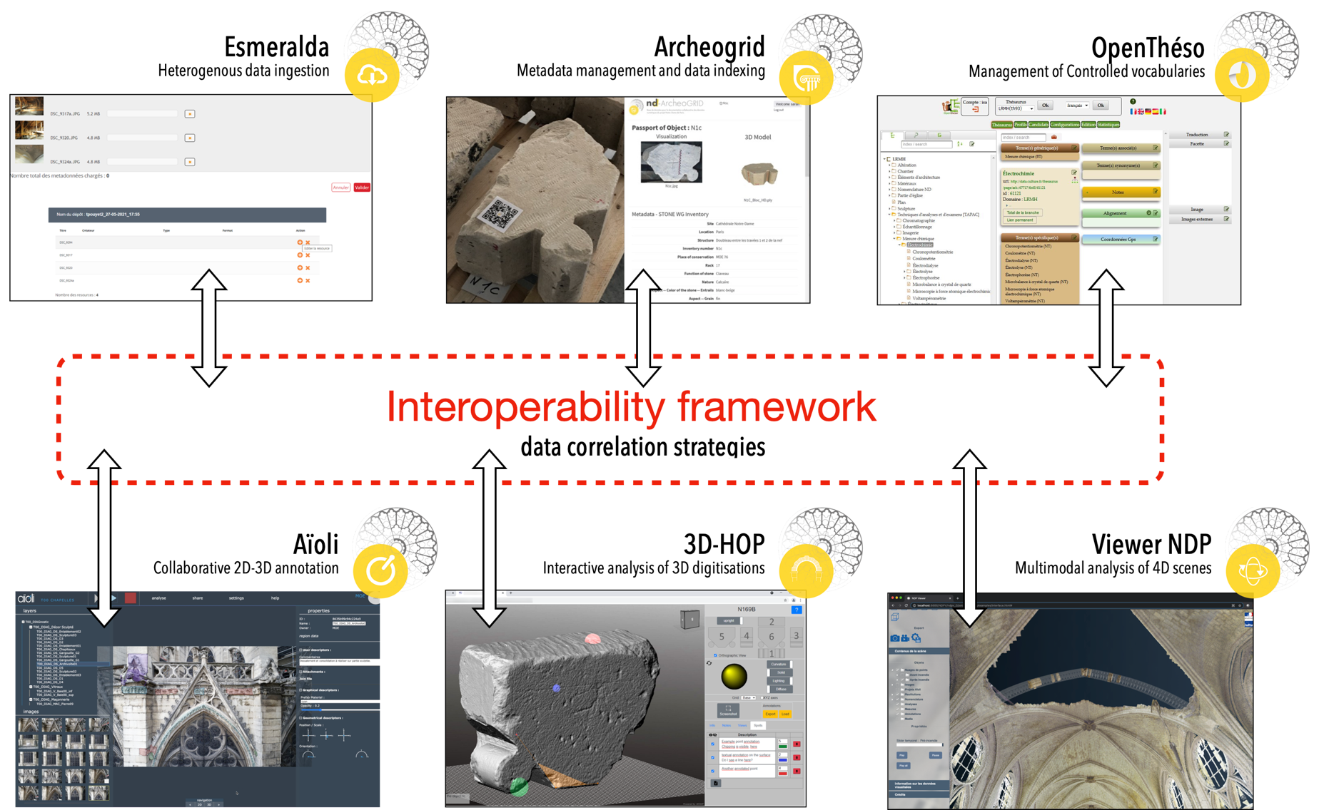
Fig. 1. Several software tools, all coming with their developers in the project, are featured in this platform. First, Esmeralda is central to data ingestion, collecting and managing diverse data types, such as photographs, and documentary sources, 3D models, … OpenTheso, facilitates vocabulary management by organizing and controlling thematic terms across different research areas, ensuring consistent and declinable definitions. Archeogrid is used for data indexing and categorisation, allowing researchers to classify digital objects based on customised metadata and paradata schemas. Additionally, Aioli provides collaborative annotation capabilities, enabling researchers to add semantic annotations directly 2D photographes to automatically spatialise them into 3D representations. The platform also integrate 3D-HOP for interactive 3D object analysis and detailed visual inspection. Finally, Viewer NDP supports multimodal visualisation, including 4D analysis, enabling the comparison of different 3D models across time periods. This tool is crucial for studying the temporal evolution of spaces and objects.


Esmeralda, web interface for data ingestion
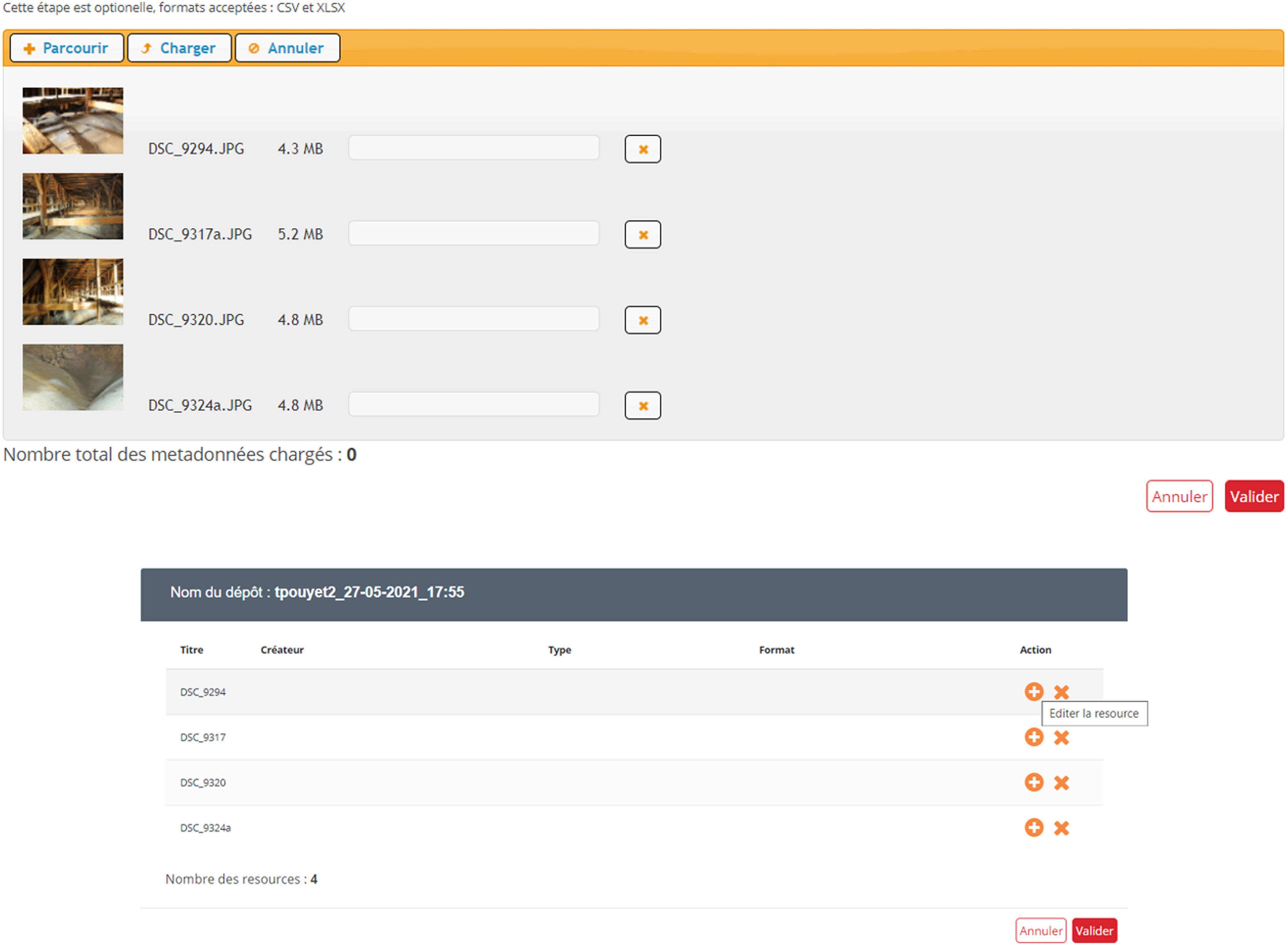
Esmeralda, a dedicated web interface, enables efficient data storage on the Huma-Num Box server, accessible only via Secure File Transfer Protocol (SFTP). It integrates and automates key functions, including normalized metadata structuring, thumbnail generation for ArcheoGRID visualization, and data transfer monitoring. The Huma-Num Box acts as a central repository for archived and frequently accessed datasets, strategically distributed across a server network. Data, with associated metadata, are organized in directories by contributing institutions, with access modalities determined by the Digital Data WG.
Users must select a metadata schema that matches their dataset’s typology, ranging from basic frameworks like Dublin Core to complex schemas tailored to specific data attributes. After choosing the schema, users upload relevant metadata, merge and fine-tune the data and metadata, and integrate controlled lexicons from Opentheso and add entries to the thesaurus. After validation, users can recover a secure data package for storage in the Huma-Num Box infrastructure.

ArcheoGRID, database for collaborative documentation of digital multimedia assets
ArcheoGRID, Archeovision
Further info on : https://www.archeogrid.fr
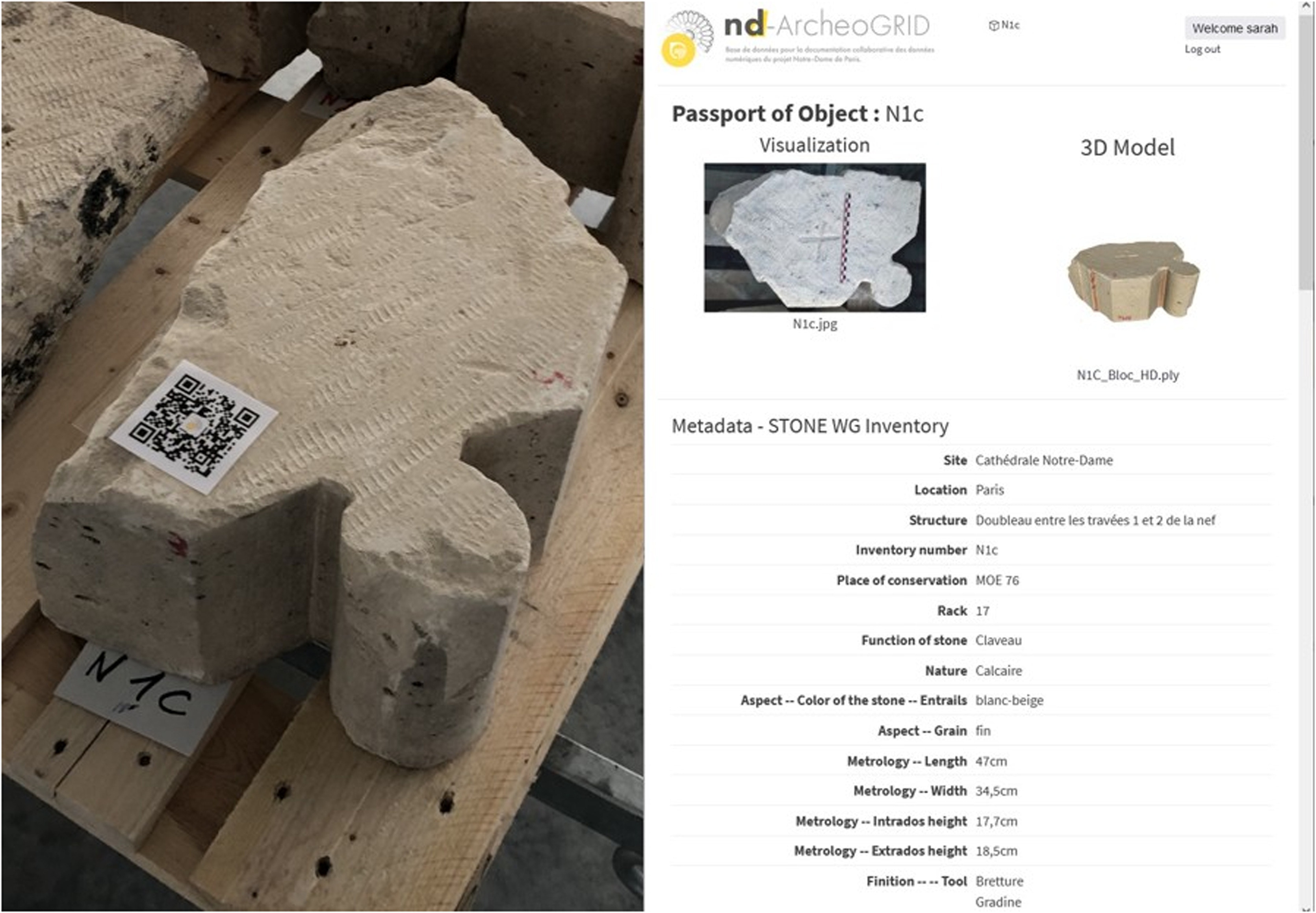
ArcheoGRID, a robust web-based environment, enables data categorization, documentation, and dissemination. Its longevity is ensured by the ability to tag data with unique identifiers (DOIs). ArcheoGRID collaborates with the National 3D Data Repository, facilitating the publication of 3D datasets and associated documentation from both sources.
ArcheoGRID supports various data and metadata schemas, seamlessly integrating the heterogeneous data spectrum of the Notre Dame project. An automated batch process ingests data and metadata from Esmeralda into a technical system. After enrichment in ArcheoGRID, data is accessible via dedicated APIs. Notably, an API extracts comprehensive resource details from ArcheoGRID and passes them to the NDP 3D Viewer. Efforts are ongoing to map metadata with CIDOCsingle bondCRM for improved data interoperability. Additionally, the integration of an IIIF image server enhances the platform’s capabilities for visualizing and annotating high-resolution images.
In the ArcheoGRID paradigm, the concept of ‘object’ connects disparate documents or metadata. This comprehensive digital passport of the object is accessible via a QR code. Some selected voussoirs analyzed by the Stone WG of the main scientific action have been equipped with this digital passport. The corresponding QR codes are attached to the physical voussoirs, allowing instant scanning to display data such as curated findings, visual material, 3D object simulations, and more.

Opentheso, thesaurus management system
Openthéso, MOM
Further info on : https://opentheso.hypotheses.org
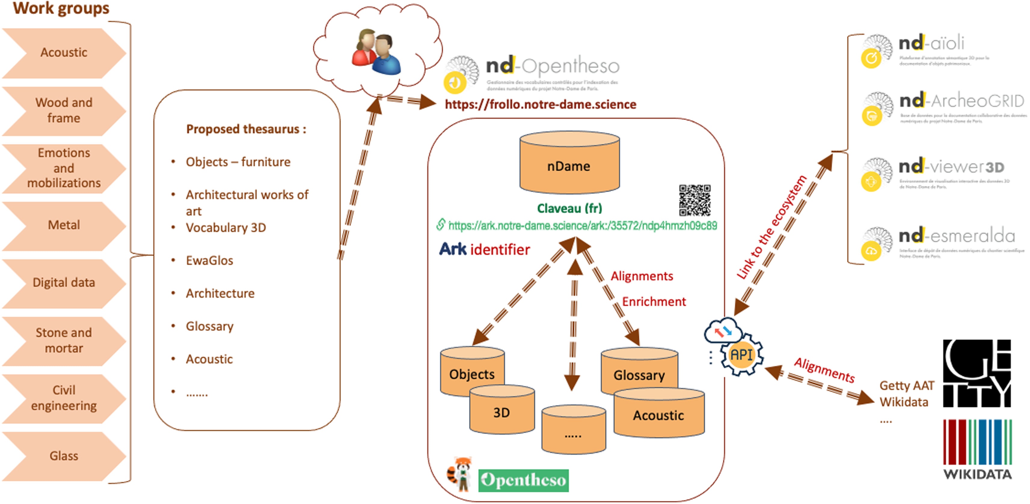
Opentheso [20], an open-source software, is developed on MOM [21] in collaboration with the FRANTIQ network [22], the MASA consortium [23], and the Huma-Num infrastructure [24]. It’s a web-centric thesaurus management system with vocabulary management and structured lexicon creation. The Notre Dame initiative’s thematic working groups developed a streamlined solution to unify and synchronize different vocabularies in a single vocabulary management system. The project used the following features:

3D-HOP, a dedicated 3D viewer for studying the voussoirs of archs
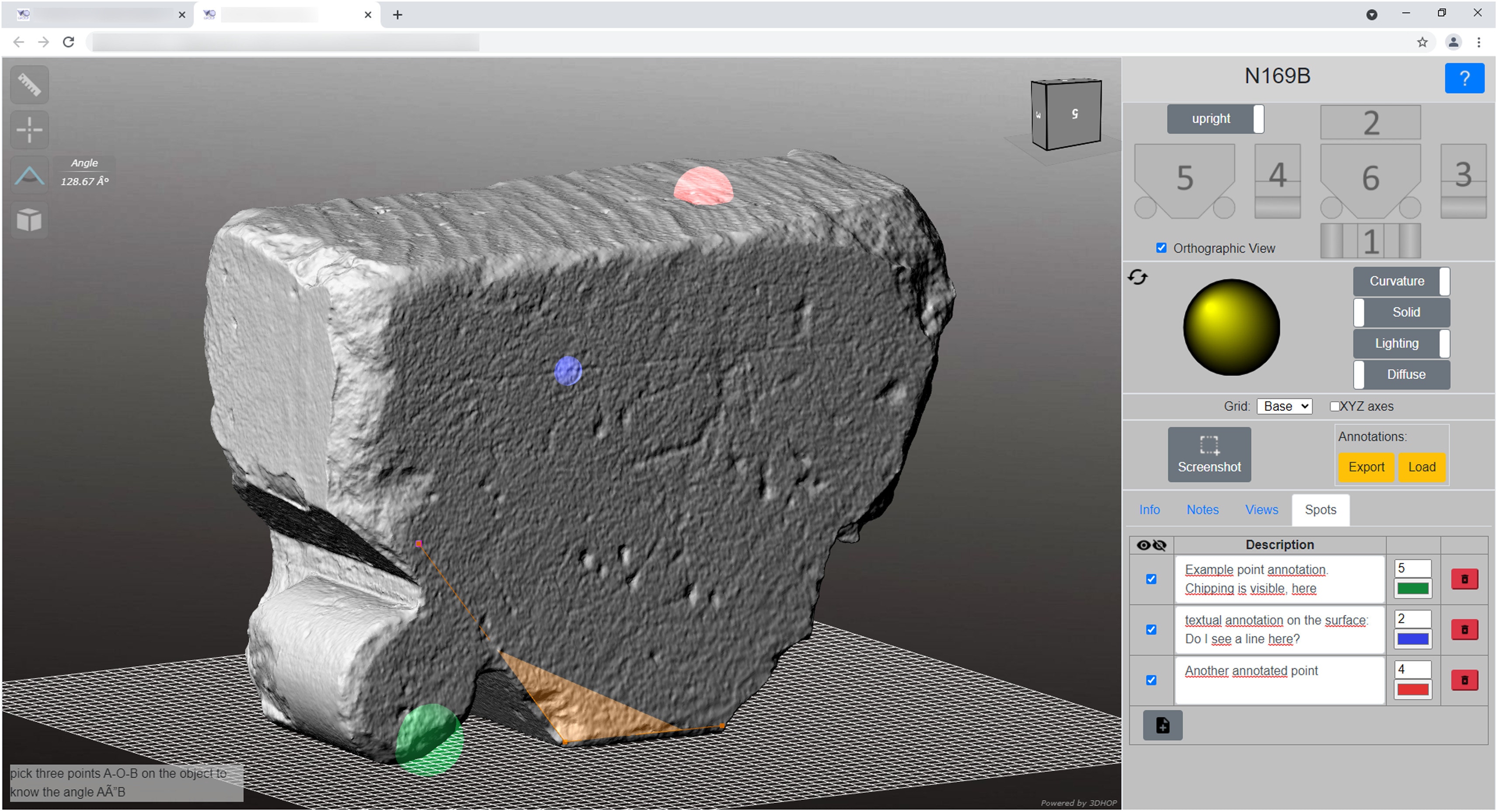
3D-HOP, Visual Computing Lab / CNR Isti
Further info on : https://3dhop.net
A voussoirs viewer was developed using 3DHOP, an open-source web framework for 3D visualization in cultural heritage applications. 3DHOP uses WebGL for native 3D rendering on all platforms and supports multiresolution encoding for high-resolution geometry. It can be customized to create tailored visualizations. The viewer offers various navigation and visualization options, including a simple two-axis turntable, object poses, predefined views, and a gizmo for orientation. Lighting, surface transparency, gloss, color, and a real-time section for cutting the voussoir are also controllable.
Interactive tools allow measuring point-to-point distances and angles on the 3D surface, with metric grids for estimating object sizes.
To support distributed collaborative exploration of the voussoirs, users can annotate 3D objects, place annotated points on the surface, and save annotated views. These views record the viewer’s status (light direction, rendering options). Annotations can be saved locally and shared with other experts. Screenshots can be saved directly via the web interface. Future work focuses on expanding annotation types to include polyline and area-based annotations.
Aïoli, integrated framework for collaborative reality-based 3D annotation

Aïoli, CNRS-MAP laboratory
Further info on : www.aioli.cloud
Aioli, a data management tool, integrates geometry, visual features, and semantics to seamlessly transition from reality-based data capture to analysis and interpretation in a collaborative environment. It links information between material objects and their digital counterparts.
Key features include:
Within Aioli, annotations can be enriched using customisable description templates. These allow users to define their own data architecture by attaching different fields: text content, dates, URLs, concepts derived from the thesaurus and even additional documents (such as images, PDFs, audio files or videos). Fields based on thesaurus concepts can be linked to Opentheso.

NDP 3D viewer, visualisation environment for the exploration of heterogeneous digital corpuses
NDP 3D Viewer, CNRS-MAP laboratory
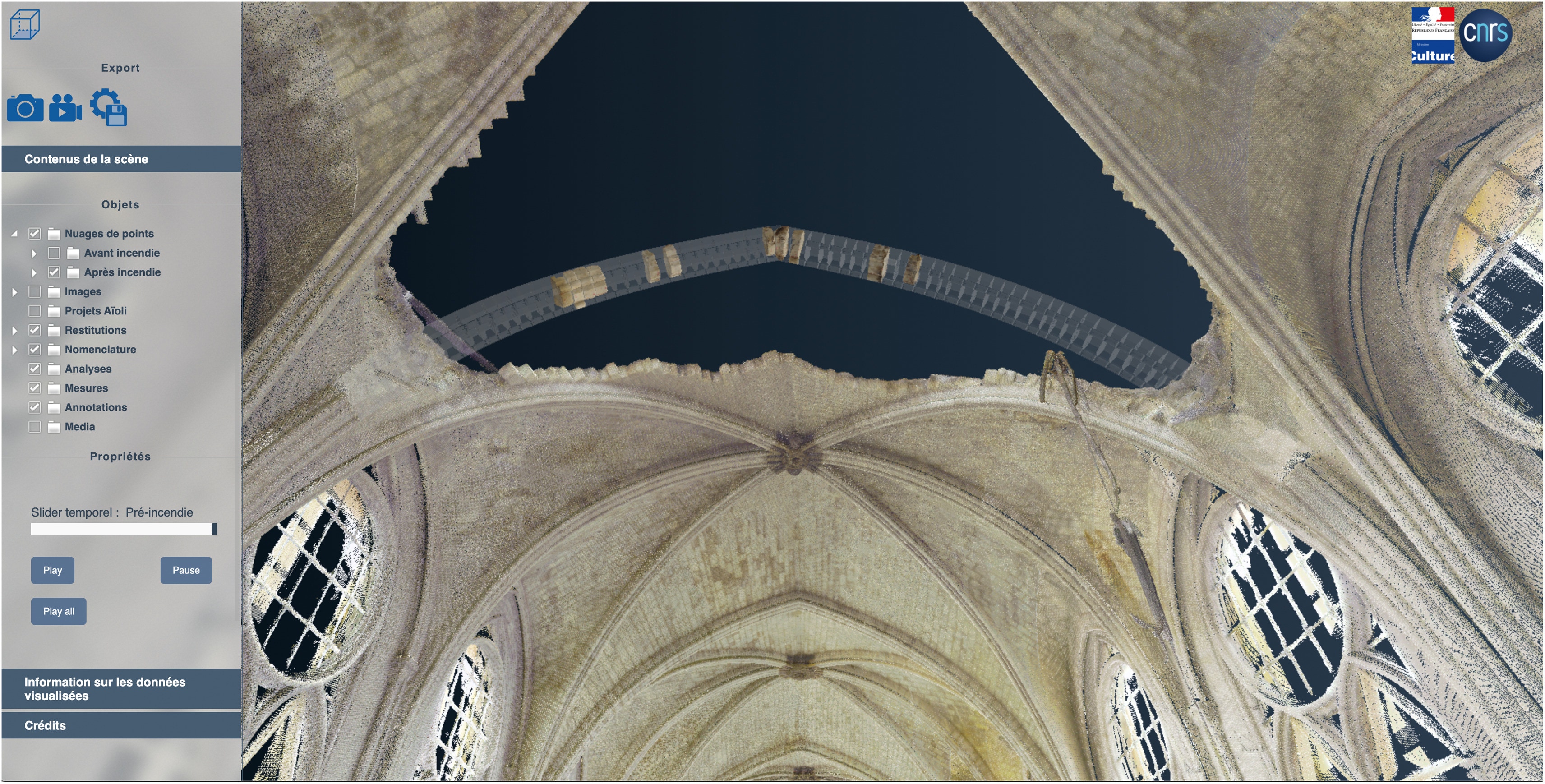
The diverse digital corpus associated with the cathedral, encompassing various file formats, geometric structures, temporal states, and focal regions, necessitated the creation of a dedicated 3D web viewer. The NDP 3D Viewer, primarily based on the PotreeJS library, spatially centralizes and aligns all digital assets related to the cathedral, regardless of their production date. This compilation requires a registration process for each data item, facilitating integrated visualisation of assets from various working groups on the Notre Dame scientific project. The aggregation promotes the discovery of correlations between analyses and observations.
Any dataset can be integrated into the viewer, provided its spatialization parameters are determined. This integration establishes a permanent link to the ArcheoGRID database, ensuring each component is linked to its corresponding metadata. The lexicon used for documentation remains accessible, promoting efficient data use and traceability. To enhance user navigation, the cathedral’s spatial domain has been divided into volumes corresponding to the restoration project’s spatial nomenclature defined in Opentheso. Users can choose to visualize specific components, such as the choir or the apse stands, or further limit themselves to a specific area. This spatially oriented categorization serves as an initial filter for the 3D visualisation. Similar principles can be applied to metadata to facilitate the creation of filters based on documentary or semantic affiliations.
The NDP 3D Viewer’s dynamic nature enables iterative improvements to meet evolving restoration and scientific research needs. Collaboration with thematic working groups integrates tailored features. For instance, the Stone Working Group led to the development of a virtual anastylosis tool for demolished vaulted arches in the cathedral nave (Fig. 6). Users can quickly evaluate hypotheses, instantiate positioning, rotation, color changes for uncertainty, and optimize export.
From Field Observation to Knowledge Graphs: quasi.modo and dür.air within the n-Dame_Heritage Platform
Within the n-Dame_Heritage ecosystem, two complementary software environments support interpretation-driven documentation and semantic exploration. dür.air focuses on in situ observation and spatio-temporal anchoring through persistent augmented reality, while quasi.modo provides a framework for integrating, querying, and analysing heterogeneous and multi-temporal data within a unified semantic space.
dür.air acts as the situated and perceptual counterpart of the quasi.modo knowledge architecture: observations are captured and interpreted in the field, then consolidated and related within interoperable knowledge graphs. Together, they articulate a continuum between augmented field observation and semantic integration, enabling cumulative and structured heritage knowledge.
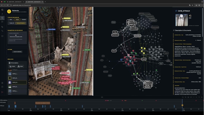
quasi.modo, Querying and Unifying Architecture for Semantic Integration of Multidimensional Orchestrated Disciplinary Observations
Quasi.modo, CNRS-MAP laboratory
Quasi.modo is a conceptual and technical architecture dedicated to the exploration, integration, and interoperability of data and knowledge produced around complex heritage objects. Its name is an acronym of "Querying and Unifying Architecture for Semantic Integration of Multidimensional Orchestrated Disciplinary Observations", expressing both its function—to query, unify, and structure—and its ambition: to articulate multiple disciplinary observations within a logic of semantic convergence.
The dot separating Quasi and modo is intentional: it marks a critical articulation. It symbolizes both a functional connector and an intellectual modularity between an open, evolving approach (quasi, "almost", "in formation") and a methodical structure (modo, "manner", "mode"). This punctuation reflects the project's nature: an interstitial space—neither rigid nor strictly normative—but orchestrated to enable the reasoned coexistence of sometimes heterogeneous disciplinary logics.
Rooted in the scientific work conducted around the restoration of Notre-Dame de Paris, the quasi.modo project seeks to enable n-dimensional semantic integration—spatial, temporal, morphological, lexical, and methodological. It offers a unified yet flexible framework, where data from 3D digitization, geolocated annotations, archives, scientific analyses, and mnemograms (spatialized narrative accounts) can be explored, linked, and queried using rigorous, documented, and adaptable research protocols.
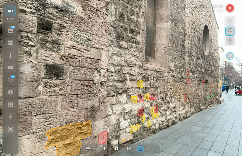
dür.air, Digital Unfolding of Reality through Augmented Interpretative Representation
Dur.air, CNRS-MAP laboratory
Within the n-Dame_Heritage project, dür.air is developed as a mobile augmented reality environment dedicated to interpretation-driven field documentation, designed to reconnect geometric acquisition with the situated production of scientific meaning. By enabling spatially and temporally anchored annotation directly during observation, the system allows researchers to generate, in situ, large volumes of semantically rich data tightly linked to their perceptual, contextual, and interpretative conditions. Persistent AR relocalisation ensures that these annotations and measurements remain coherently aligned across successive field campaigns, while bidirectional projection between images, depth maps, and photogrammetric models supports their reuse and refinement during later analytical phases. In this way, dür.air contributes to the n-Dame_Heritage ecosystem by transforming fieldwork into a cumulative process of semantic enrichment, where observations, hypotheses, and interpretations are recorded within a stable spatio-temporal framework and can be integrated with the broader knowledge infrastructure of the project.
Further info
